Cicling itineraries
Bike wandering countries on the lake
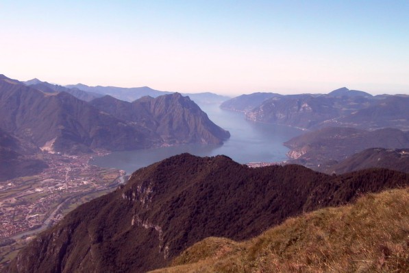
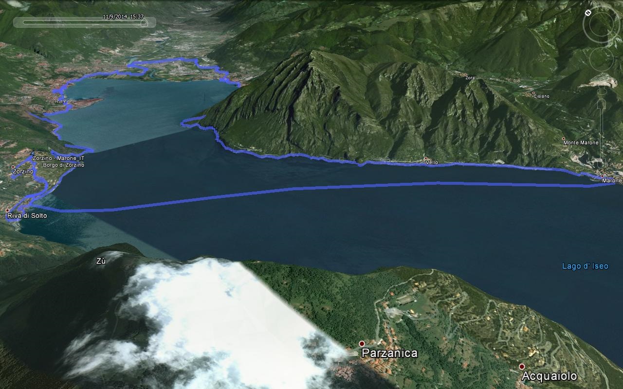
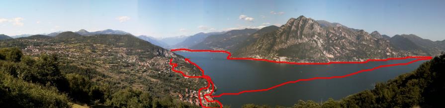
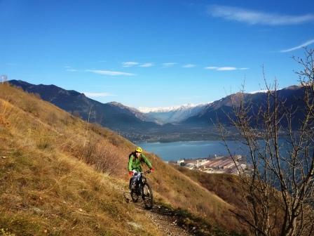
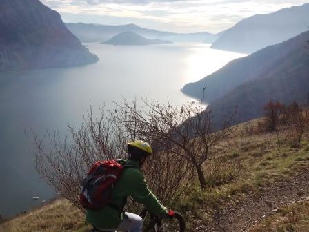
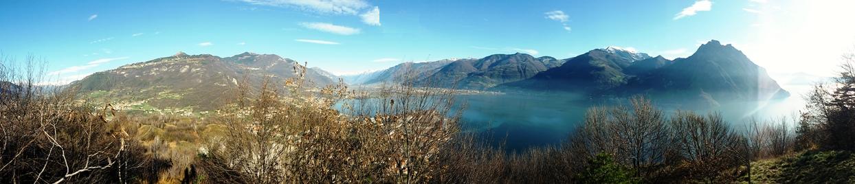
We go down to the town of Riva di Solto through the old town with narrow streets of old fishermen, we pass to the inlet of the singular Bogn Zorzino, regional geological site, then walk along the scenic coastal road coming to Castro that cross bringing in Lovere, we pass for most charming, historic city center and the waterfront can also visit some prominent buildings, we go over Lovere Pisogne using minor roads between fields and along the bank of the river Oglio. Let's move on to the church where the Romanino left wonderful paintings, cross the beautiful old town, then on his lakefront. Now we walk the path "Vello Toline" the pearl of the lanes on Lake Iseo. Once in Marone we return by boat to Riva di Solto and from there to Zorzino.
For info on ferry schedules for the return of Riva Solto visit the following website:
http://www.navigazionelagoiseo.it/ (Unfortunately, until March 28, 2015 there are links between the bank and Marone Bergamo).
Or you can take the path up to Iseo and Sarnico (1.30 hours) planning the return by boat or by train (by this means only between Iseo and Pisogne) or complete around the lake knowing that the stretch between Sarnico and Riva di Solto is on the road (not too busy) and tunnel sections (2.15 hours from Marone).
SHEET
|
Check in: |
Zorzino via Principale 37 (Parking Church) |
|
Check-out: |
Zorzino via Principale 37 (Parking Church) |
|
Distance: |
31,12 km + crossing by boat 7 km |
|
Estimated time: |
3,50 h add long stops |
|
Maximum Height: |
350 m |
|
Minimum Height: |
190 m |
|
Elevation start: |
350 m |
|
Height arrival: |
350 m |
|
Total ascent: |
277 m |
|
Downhill total: |
277 m |
|
Max slope: |
10 % |
|
Slope min: |
-20 % |
|
Recommended Period: |
Spring, summer, autumn. With appropriate clothing is possible even in winter |
|
preparation: |
normal, weekly releases |
|
Classification: |
CAI: |
|
Technical difficulties: |
Easy: paved roads and short stretches in dirt, some sections with high traffic roads |
|
Cartography |
Kompass kom 104 Alpi Orobie bergamasche; oder KOM 106 Lago d'Iseo, Valle Trompia, Franciacorta kom 106 1:50.000 |
|
Parking: |
Zorzino |
|
Locations' transited: |
Zorzino, Gargarino, Riva di Solto, Castro, Lovere, Pisogne, Toline, Vello, Marone |
|
recommended bicycles |
City bike, mountain bike, suitable for any type of bicycle |
Map Multilingual and file for GPS
Download file with GPX waypoint in English for GPS
____________________________________
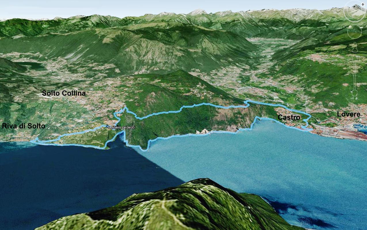
Path of holm
It starts from Zorzino going up steep paths (for the strongest) or for passing lanes from the town of Solto Collina, flat traverse then for two kilometers halfway up the lake with short push, great view and environment, achieved then the gorge Poltragno descend on old path to Castro and you fall from charming coastal road passing through the inlet singular Bogn Zorzino, regional geological site, stop in Riva di Solto to regain his strength and return on a Zorzino.
SHEET
|
Check in: |
Zorzino via Principale 37 (Parking Church) |
|
Check-out: |
Zorzino via Principale 37 (Parking Church) |
|
Distance: |
14,12 km |
|
Estimated time: |
2,30 h |
|
Maximum Height: |
569 m |
|
Minimum Height: |
341 m |
|
Elevation start: |
350 m |
|
Height arrival: |
350 m |
|
Total ascent: |
323 m |
|
Downhill total: |
323 m |
|
Max slope: |
33 % |
|
Slope min: |
-32 % |
|
Recommended Period: |
Spring, summer, autumn. With appropriate clothing as possible, even in winter. |
|
preparation: |
|
|
Classification: |
CAI: |
|
Technical difficulties: |
Short steeper uphill single trail, half asphalt path, short stretches inportage, the rest with medium difficulty |
|
Cartography: |
Kompass kom 104 Alpi Orobie bergamasche 1:50.000 |
|
Parking: |
Zorzino parking church |
|
Locations' transited: |
Zorzino Solto Collina, Esmate, Castro, Riva di Solto. |
|
recommended bicycles |
MTB All Mountain or at least front |
Map Multilingual and file for GPS
Download file with GPX waypoint in English for GPS
____________________________________
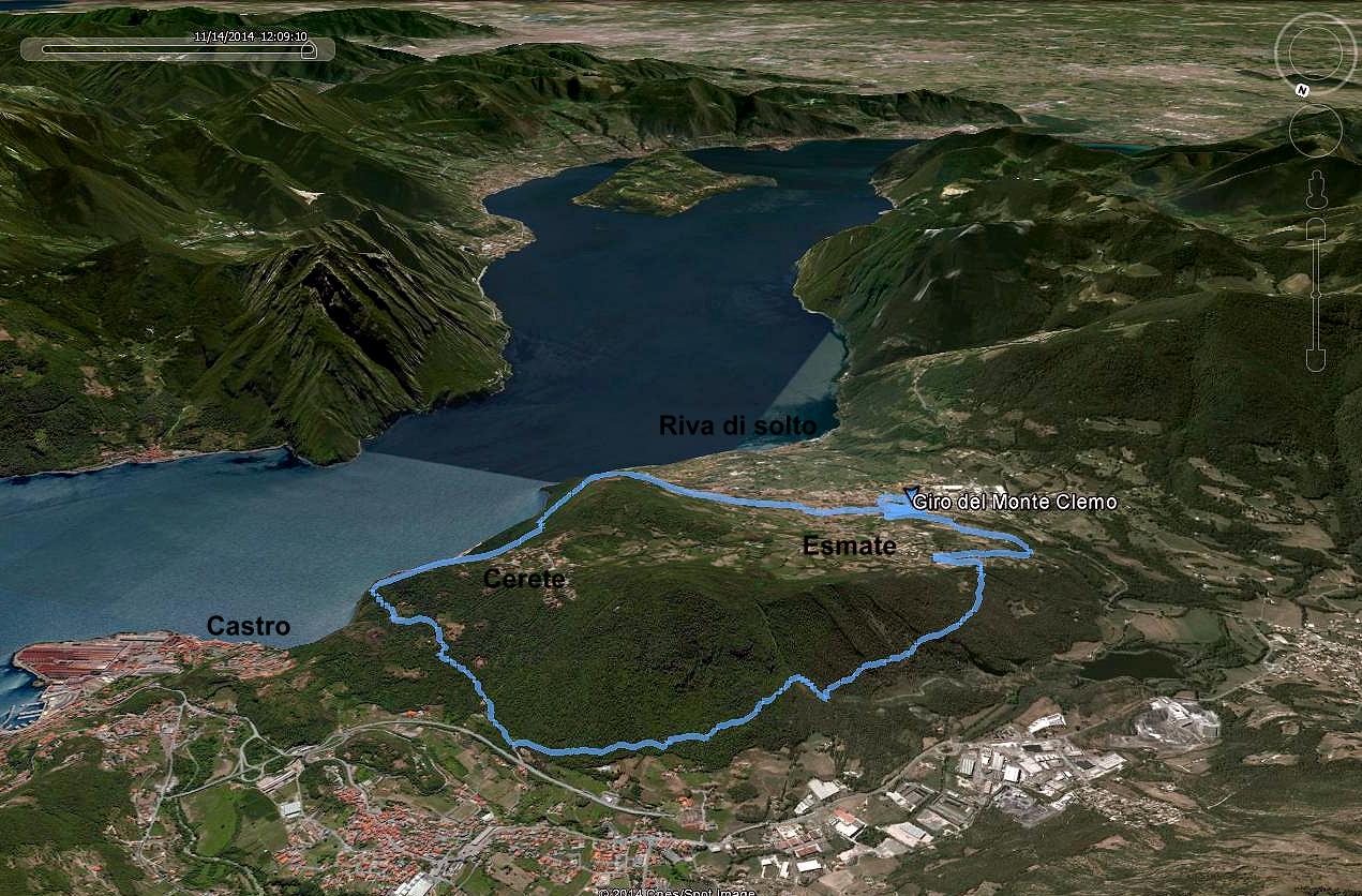
Tour of Mount Clemo
It starts from Solto Hill is easily accessible from Zorzino, and crossing streets to the old town is just a dirt road, in the plan is then to cross three kilometers halfway up the lake with short push on the path, great views and environment with trail descend towards Pianico, just before you go up to steep but pedaled up to the valley of the Cold, nature reserve, with beautiful hairpins downhill after we reach the ridge of the mountain and dirt roads on the plateau we return to the starting point.
SHEET
|
Check in: |
Solto Collina , via s Rocco 181 |
|
Check-out: |
Solto Collina , via s Rocco 181 |
|
Distance: |
11,70 km |
|
Estimated time: |
2,30 h |
|
Maximum Height: |
582 m |
|
Minimum Height: |
328 m |
|
Elevation start: |
440 m |
|
Height arrival: |
440 m |
|
Total ascent: |
494 m |
|
Downhill total: |
494 m |
|
Max slope: |
35 % |
|
Slope min: |
-40 % |
|
Recommended Period: |
Spring, summer, autumn. With appropriate clothing as possible, even in winter if devoid of snow |
|
preparation: |
|
|
Classification: |
CAI: |
|
Technical difficulties: |
Steep uphill part in single trail, whether in portage, the rest withmedium difficulty |
|
Cartography: |
Kompass kom 104 Alpi Orobie bergamasche 1:50.000 |
|
Parking: |
Solto Collina , via s Rocco 181 |
|
Locations' transited: |
Solto Collina, Esmate, Pianico |
|
recommended bicycles |
MTB All Mountain or at least front |
Map Multilingual and file for GPS
Download file with GPX waypoint in English for GPS
____________________________________
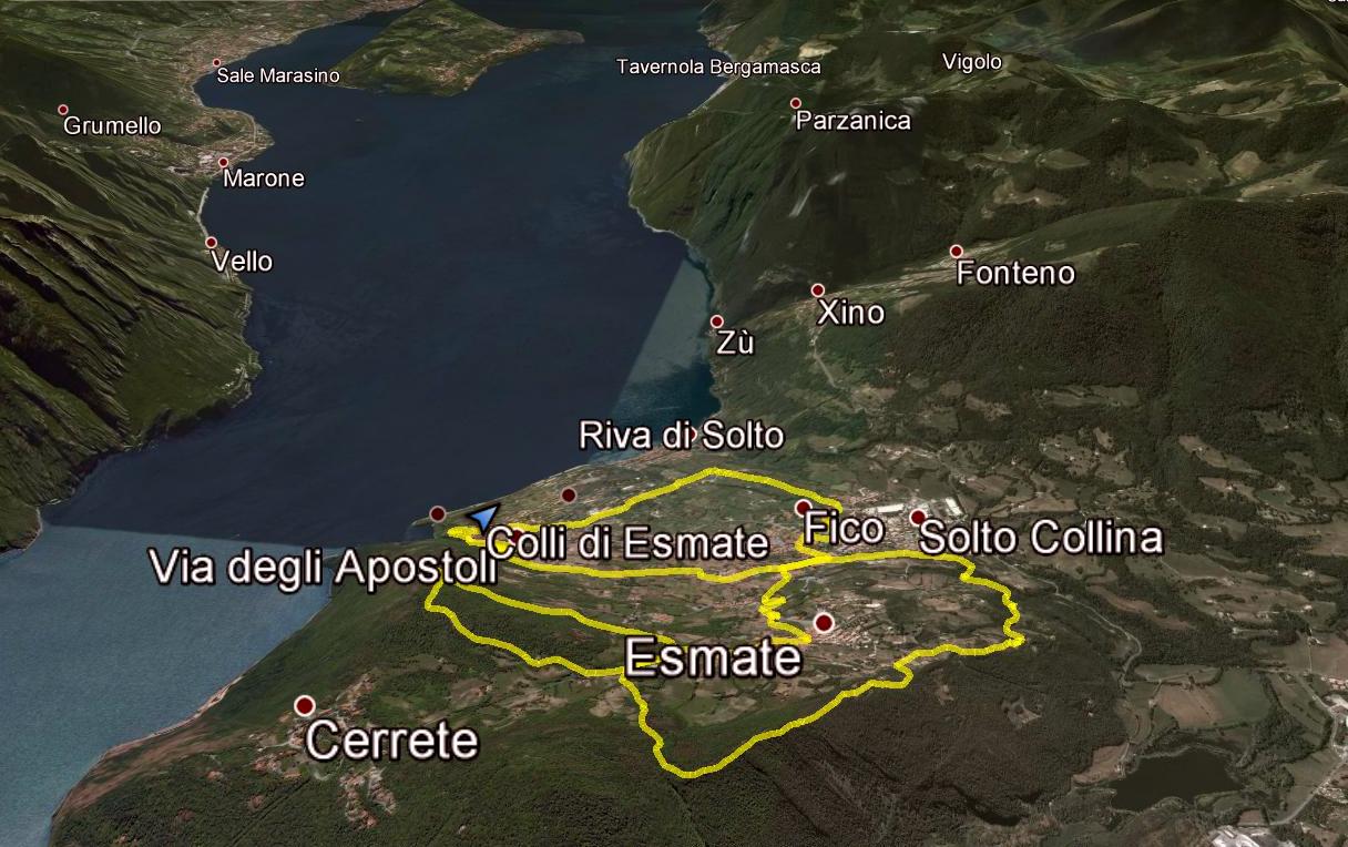
Around the hills of Esmate
It starts from Zorzino or from Solto Hill, is a ride that lends itself to variations but that targets the walk through the streets and trails, to little villages and sights, including curiosity, olive groves and history.
SHEET
|
Check in: |
Zorzino via Principale 37 (Parken Church), oder Solto Collina via s Rocco 181 |
|
Check-out: |
Zorzino via Principale 37 (Parken Church), oder Solto Collina via s Rocco 181 |
|
Distance: |
13,13 km |
|
Estimated time: |
2,30 h |
|
Maximum Height: |
706 m |
|
Minimum Height: |
328 m |
|
Elevation start: |
328 m |
|
Height arrival: |
328 m |
|
Total ascent: |
590 m |
|
Downhill total: |
590 m |
|
Max slope: |
35 % |
|
Slope min: |
-40 % |
|
Recommended Period: |
Spring, summer, autumn. With appropriate clothing as possible, even in winter. |
|
preparation: |
good technical skills and training |
|
Classification: |
CAI: |
|
Technical difficulties: |
Short steeper uphill single trail, half asphalt path, short stretches inportage, the rest with medium difficulty |
|
Cartography: |
Kompass kom 104 Alpi Orobie bergamasche 1:50.000 |
|
Parking: |
Zorzino parking church or Solto Collina , via s Rocco 181 |
|
Locations' transited: |
Zorzino Solto Collina, Esmate. |
|
recommended bicycles |
MTB All Mountain or at least front |
Map Multilingual and file for GPS
Download file with GPX waypoint in English for GPS